
Urban flood simulation,
from runoff to report.
iFloodSim is Zygorix's hydraulic simulation engine. Draw a boundary, configure a storm, and in minutes get water-depth maps, at-risk buildings, and a client-ready engineering report — all from a single run.
Six subsystems, one run
Explore each module individually — the same panels shown in the iFloodSim console after every simulation.
Tap a subsystem
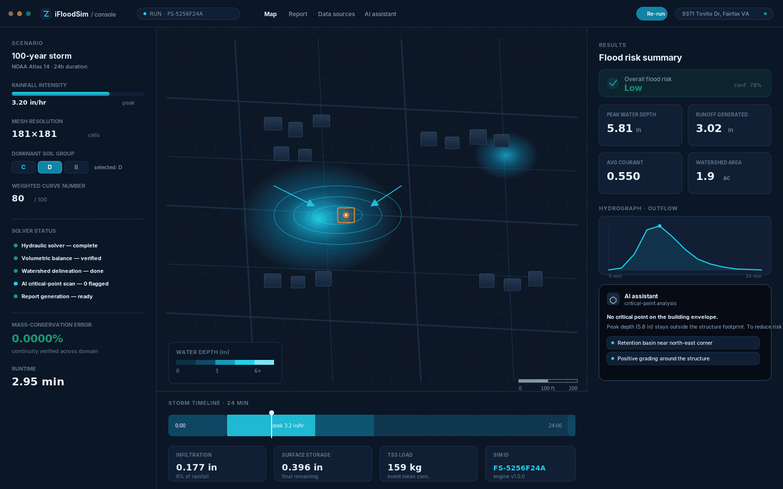
2D GPU-accelerated solver
The core surface-flow engine solves runoff equations on a dense computational mesh, tracking depth, velocity, and flow path in every cell.
Peak rainfall intensity
3.20 in/hr
Peak water depth
5.8 in
Peak flow velocity
2.1 ft/s
Runtime
2.95 min
- Physically based runoff modeling calibrated to each parcel's real soil conditions
- Continuous numerical-stability monitoring to guarantee a convergent solution
- Near-zero mass-conservation error at the end of every run
When a critical point is found,
the fix is already ready
The AI assistant isn't just a chatbot — it's a scenario-evaluation engine that reads the existing drainage network, applies proven mitigation solutions to critical points, benchmarks them with comparative simulation, and hands the engineer only the top options.
Suggests mitigation layouts
For every critical point, multiple intervention layouts — retention basin, green swale, larger inlet — are generated deterministically.
Automatic scenario validation
Before a result is shown, invalid layouts are rejected by the model's safety guards so only buildable solutions remain.
Compares scenarios and picks the best
A comparative simulation runs across top candidates, and solutions are ranked by depth reduction and building risk.
AI assistant
iFloodSim · scenario analyst
An engineering report, ready for your client
iFloodSim output isn't a raw simulation image — it's a structured engineering document with an executive summary, flood mechanism, 3D maps, model configuration tables, critical-point list, data sources, and final conclusion — with a unique reference ID for every run.
- Executive summary and risk level for project managers
- Full hydraulic configuration tables for engineers and reviewers
- Data source list, assumptions, and model limitations
Flood Engineering
Assessment Report
9371 Tovito Drive, Fairfax, Virginia
No number appears in the report without a known source
Every input layer's provider, status, and resolution is documented in the data-source record of every run.
| Data layer | Provider | Description | Status |
|---|---|---|---|
| Elevation & terrain | High-resolution public elevation surveys | Region-wide validated terrain, not just basemap elevation | Live |
| Soil composition | National soil survey records | Detailed soil-unit mapping for infiltration analysis | Live |
| Land cover | Standardized land-cover classification | Consistent resolution across the project area | Live |
| Building footprints | Verified structural footprint data | Feature-level, per building | Live |
| Streets & pavement | Public infrastructure & road network data | Streets, pavement, curbs, and gutters | Live |
| Live stream gauge | Public hydrologic monitoring networks | Nearest active gauge to the project site | Live |
| Rainfall | Standard precipitation-frequency data or manual hyetograph | Standard return periods | Live |
| Runoff method | Physically based infiltration modeling | Calibrated to local soil texture and drainage characteristics | Live |
Every number in the report is traceable
Instead of one definitive number, iFloodSim reports the confidence level of each input source — terrain, soil, land cover, rainfall — separately, so the engineer knows exactly what to rely on and where a field visit is still needed.
- Full volumetric balance of rainfall, infiltration, runoff, and final storage per run
- Continuous numerical-stability monitoring to ensure a convergent solution
- Full record of the source, status, and resolution of every data layer in the final report
Mass-conservation error
0.0000%Checks continuity of water volume across the full computational domain
Numerical stability index
0.000Confirms the solver stays within a numerically stable range
Elevation model accuracy
0%Based on high-resolution public elevation surveys
Overall model confidence score
0%Combines terrain, soil, rainfall, and building-footprint accuracy
Engineering limitations & responsible use
Let's build the engineering baseline for your next decision
Talk to the Zygorix team about your project, your watershed, or your portfolio — and see a live simulation run on your own boundary.